Models of Abandonment
Infrastructure Systems Analysis and Governance Framework
Role: Systems Research, Analysis and Environmental Governance Design Lead
Type: Geospatial Infrastructure Study and Civic Governance Framework
Stack: QGIS, Python, MATLAB, ArcGIS, LiDAR, AutoCAD Civil 3D, BIM
Region: United Kingdom
Overview
Models of Abandonment is a research framework examining post-industrial infrastructure as designed systems where maintenance withdrawal, financial restructuring, and ecological degradation operate as coordinated processes rather than passive decay. The project developed geospatial analysis methodologies and governance protocols treating abandonment as infrastructural choreography—strategic suspension of care resetting property values, redistributing risk, and reauthorizing ownership through cyclical capital metabolism.
The research integrated remote sensing, BIM forensics, and civic governance simulation to propose Observation Nodes—hybrid civil-civic laboratories pairing engineering diagnostics with accountability frameworks. Each node functions as multi-scalar sensing infrastructure where material stress, financial exposure, and public participation are co-measured, enabling data-driven negotiations around infrastructure reuse and remediation.
Abandonment is not the failure of design; it is its most sophisticated form.

England became a model environment.
Peter Halls study of the containment of urban form in 1974 clearly defines the workings of this algorithm:
- Containment
- Suburbanisation
- Inflation
Left: English town planner, urbanist and geographer Peter Hall (1932 - 2014), UK, 6th July 1973. (Photo by Bob Haswell/Daily Express/Hulton Archive/Getty Images)
Right: Still from British New Towns: Runcorn documentary (1974)
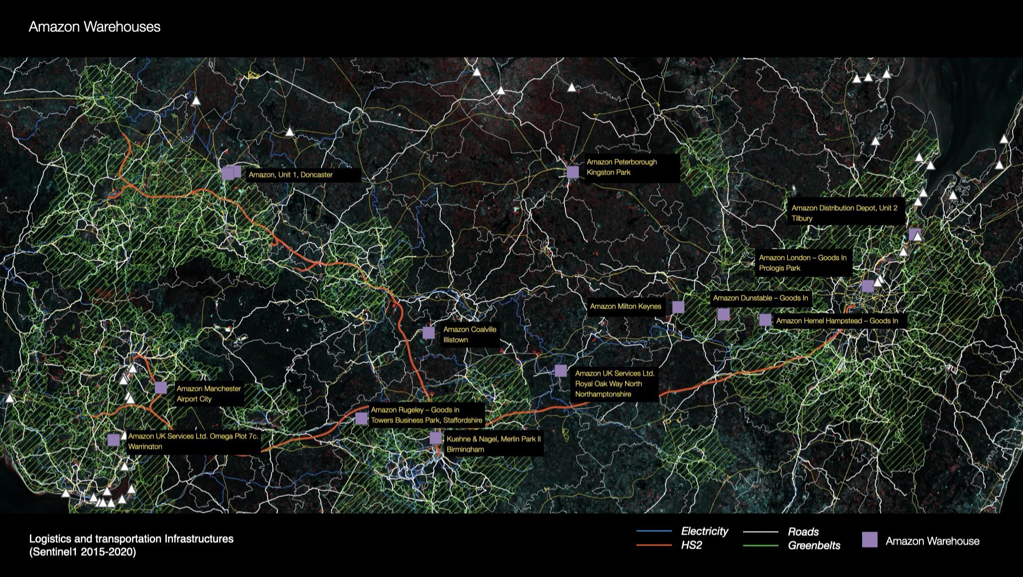
Data: Sentinel 1 multitemporal 2015-2020, DLUHC: English local authority Green Belt (latest polygons, WGS84), HS2 safeguarded area (planning.data.gov.uk), Ordnance Survey – OS Open Roads, Canal & River Trust Open Data Portal
Flourishing in the semi-peripheral space between greenbelts and towns.
Data: Sentinel 1 multitemporal 2015-2020, DLUHC: English local authority Green Belt (latest polygons, WGS84), HS2 safeguarded area (planning.data.gov.uk), Ordnance Survey – OS Open Roads, National Grid (Electricity Transmission) route maps & open data, Canal & River Trust Open Data Portal
Problem Space
Post-industrial regions exhibit patterns where infrastructure deterioration, property devaluation, and ecological damage occur as coordinated rather than random processes. Existing infrastructure assessment methodologies treat abandonment as technical failure requiring engineering intervention, missing how financial mechanisms (depreciation schedules, deferred maintenance, asset rotation) actively produce decline as prerequisite for redevelopment.
Technical challenge: develop analytical frameworks revealing how logistics, energy, and information infrastructures form scaffolding for spatial governance. This required integrating heterogeneous data sources (geospatial scans, financial records, policy documents, environmental monitoring), modeling feedback loops between material degradation and regulatory responses, and proposing governance mechanisms binding infrastructure performance to civic accountability.
Conventional approaches either focused on engineering diagnostics without examining financial incentives producing neglect, or analyzed economic patterns without quantifying material consequences. The research required coupling civil engineering (material performance, load paths, degradation) with civic engineering (visibility, regulation, public narrative) to reveal abandonment as dual technology.
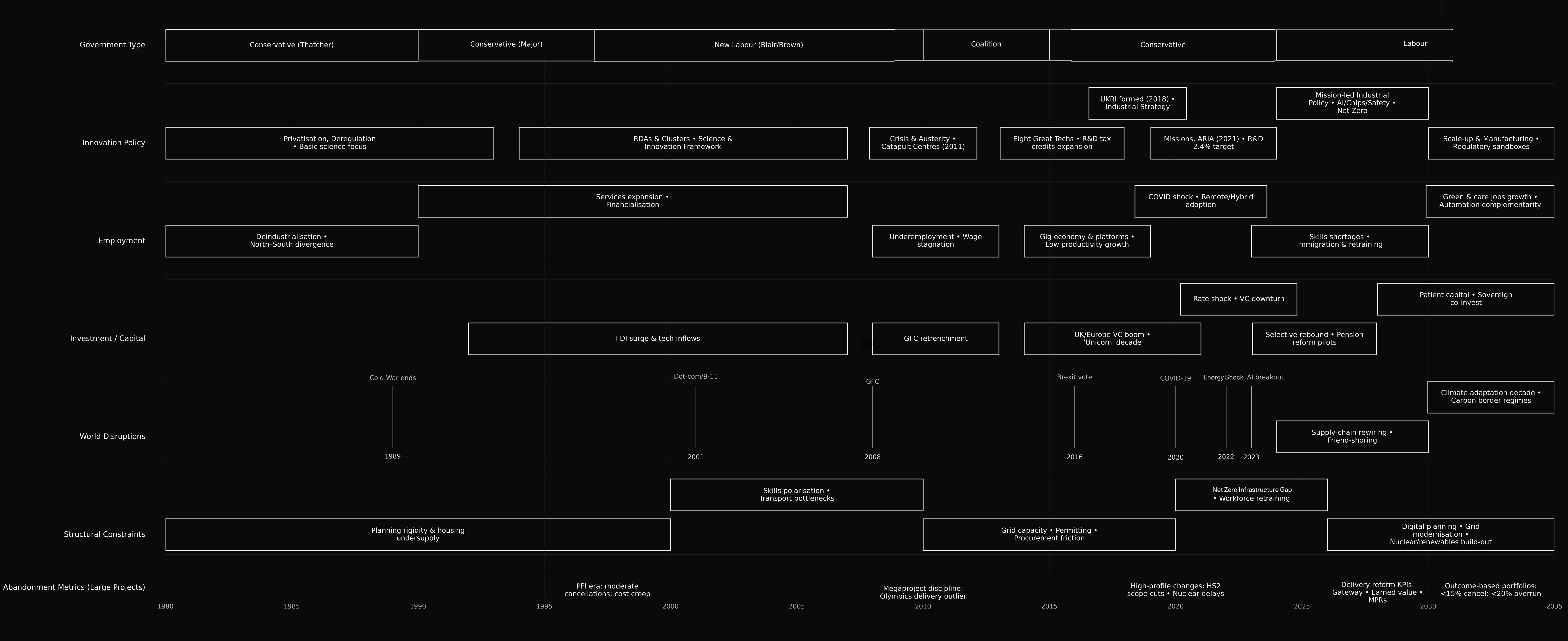
a curated synthesis of UK public sources (Parliament/legislation, HM Treasury, ONS, UKRI/Innovate UK, NAO/IPA, BoE/OBR, OECD/World Bank) with approximate date bands for readability.
Technical Architecture
Models of Abandonment proposed Observation Nodes—integrated analysis and governance infrastructure combining remote sensing, simulation, and participatory protocols:
Geospatial scanning and analysis (LiDAR, satellite, UAV photogrammetry, QGIS, ArcGIS):
Multi-temporal satellite imagery (Sentinel, Landsat) tracking dormant corridors, freight depots, and industrial sites. LiDAR scanning generating high-resolution elevation models documenting structural degradation. UAV photogrammetry capturing site conditions inaccessible to ground surveys. QGIS and ArcGIS workflows processing point clouds and imagery into queryable spatial databases documenting infrastructure condition over time.
Network and flow analysis (MATLAB, AutoCAD Civil 3D, Python NetworkX):
Graph analysis revealing latent network capacities in underutilized rail corridors, power transmission infrastructure, and logistics networks. NetworkX calculating betweenness centrality identifying strategic intervention points where modest infrastructure investments unlock broader system connectivity. AutoCAD Civil 3D modeling flow dynamics (energy, freight, water) through existing infrastructure under different reactivation scenarios.
BIM forensics and systems modeling (Revit, Python):
Building Information Modeling integration with legacy infrastructure documentation. Combining historical construction records with current sensor data to benchmark systemic fatigue. Python scripts automating extraction of geometric, material, and performance data from BIM models, enabling computational analysis of degradation patterns across infrastructure portfolios.
Resilience and degradation modeling (Python, CloudCompare, MATLAB):
Computational models simulating network degradation under different maintenance scenarios. CloudCompare processing point cloud time-series to quantify structural deformation rates. MATLAB system dynamics models examining feedback loops between deferred maintenance, property values, and regulatory enforcement. Python scripts (NumPy, SciPy) calculating infrastructure resilience metrics under shock scenarios (economic downturns, climate events).
Environmental monitoring integration:
Cross-referencing infrastructure condition data with environmental indicators (PM2.5 particulate matter, chemical oxygen demand in waterways, heavy goods vehicle emissions). Spatial analysis revealing correlations between infrastructure neglect and ecological degradation, enabling quantification of environmental externalities.
ISO 19650-compliant data frameworks:
Standardized data exchange protocols enabling integration across engineering datasets, financial records, regulatory databases, and civic monitoring systems. Federated database architecture letting stakeholders maintain data sovereignty while participating in shared analysis.
Governance and civic protocols (proposed frameworks):
- Performance-Indexed Leases (PILs): Contractual frameworks binding financial obligations to ecological compliance metrics, translating environmental performance into enforceable lease terms
- Community Equity Tranches (CETs): Mechanisms converting public subsidy into non-dilutable community ownership stakes
- Open Ledger Covenants (OLCs): Real-time auditable dashboards making infrastructure performance and financial flows publicly accessible
- Consent Protocols: Structured processes ensuring free, informed, and revocable civic participation in infrastructure decisions
- Harm/Benefit Ledgers: Accounting frameworks quantifying environmental and social impacts per site, enabling evidence-based compensation and remediation prioritization

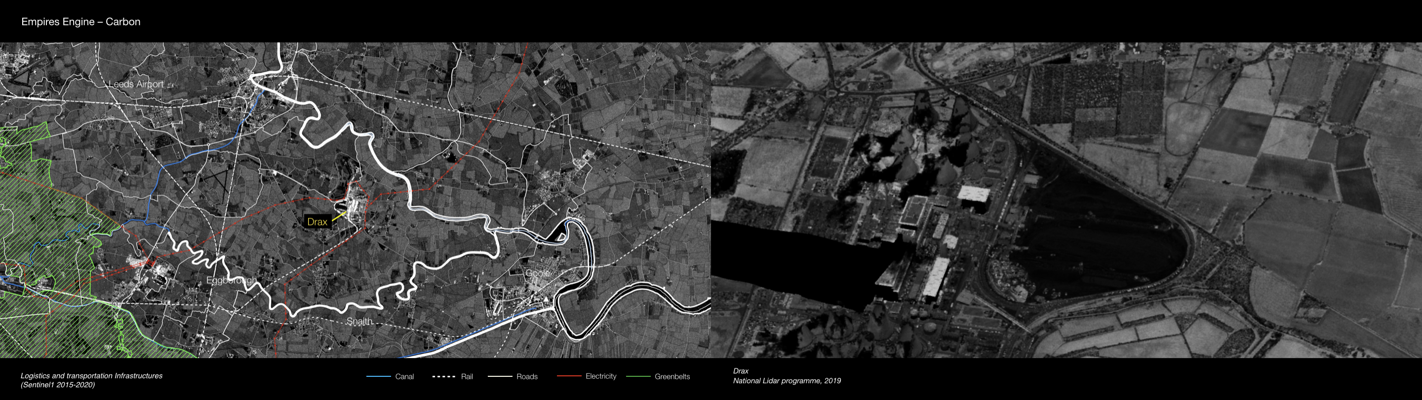
Drax claims to be 100% renewable. Burns wooden pellets since 2021. It has been dropped from the sustainability index, as its co2 emissions are some of the worst in comparison to Europe.
Data: Sentinel 1 multitemporal 2015-2020, DLUHC: English local authority Green Belt (latest polygons, WGS84), HS2 safeguarded area (planning.data.gov.uk), Ordnance Survey – OS Open Roads, Canal & River Trust Open Data Portal
Data: Sentinel 1 multitemporal 2015-2020, DLUHC: English local authority Green Belt (latest polygons, WGS84), HS2 safeguarded area (planning.data.gov.uk), Ordnance Survey – OS Open Roads, Canal & River Trust Open Data Portal
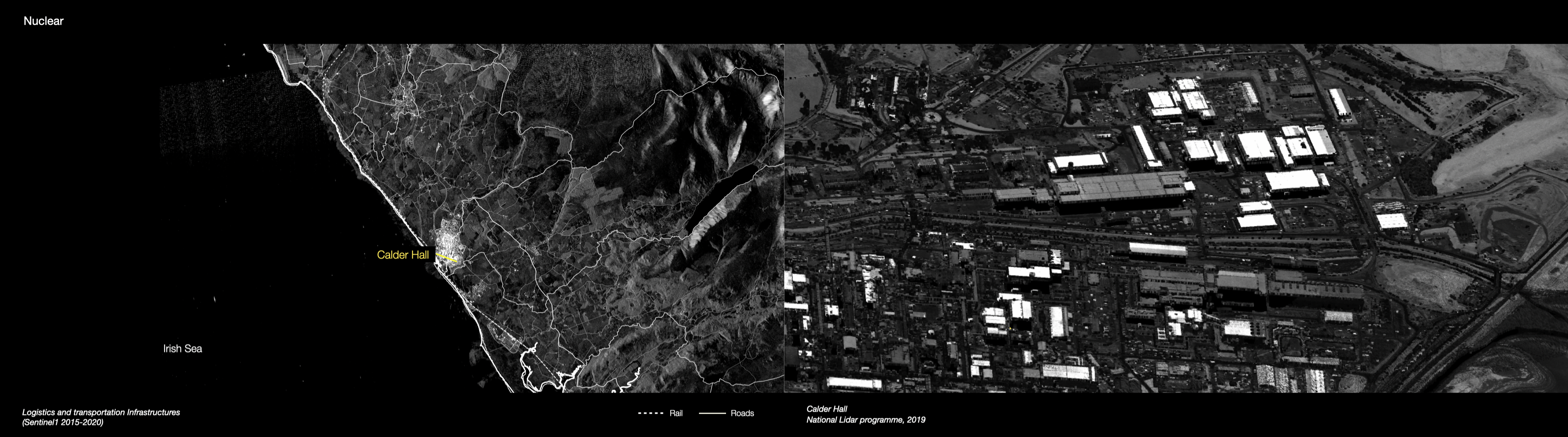
Rolls-Royce is leading a consortium to build small modular reactors (SMRs) and install them in former nuclear sites in Cumbria or in Wales. Ultimately, the company thinks it will build between 10 and 15 of the stations in the UK. They are about 1.5 acres in size - sitting in a 10-acre space. That is a 16th of the size of a major power station such as Hinkley Point.
SMRs are so small that theoretically every town could have its own reactor...
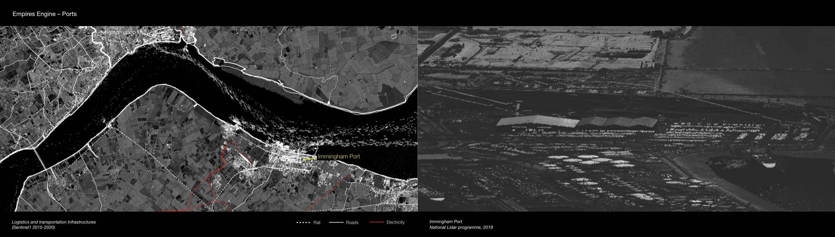
Data: Sentinel 1 multitemporal 2015-2020, DLUHC: English local authority Green Belt (latest polygons, WGS84), HS2 safeguarded area (planning.data.gov.uk), Ordnance Survey – OS Open Roads, Canal & River Trust Open Data Portal
Research Methodology
The project models abandonment as feedback process operating through recursion between data collection, regulatory response, and financial speculation:
Information loop: Sensor data (structural monitoring, environmental telemetry) feeding infrastructure revaluation models. Analysis revealed how improved monitoring paradoxically enables deferred maintenance—better data quantifying degradation rates lets asset owners calculate optimal delay before intervention becomes legally mandatory.
Regulatory loop: Policy frameworks triggering selective compliance enabling repair deferral. Examined how regulatory thresholds (e.g., "structurally deficient" vs. "functionally obsolete" classifications) create incentive structures where owners optimize for categories minimizing legal obligation while maximizing asset optionality.
Financial loop: Credit instruments determining when decay becomes profitable. Analyzed depreciation schedules, insurance mechanisms, and redevelopment financing revealing how infrastructure neglect functions as deliberate strategy resetting property values before capital reinvestment. Abandonment operates as phase in asset lifecycle rather than endpoint.
Sociotechnical loop: Public pressure modulating when regeneration is declared politically necessary. Quantified how civic visibility (media coverage, protests, health data) affects regulatory enforcement timelines and funding allocation.
Computational models demonstrated how these loops interact: improved sensing enables financial optimization of neglect, regulatory gaps create incentive misalignment, civic pressure triggers punctuated interventions rather than continuous maintenance, producing cyclical rather than linear infrastructure trajectories.

Six-phase observation methodology:
- Scoping: Corridor selection based on latent public value (connectivity, ecological function, community need)
- Signal Harvesting: Data aggregation across civil (sensors, scans) and civic (complaints, violations, health outcomes) sources
- Systems Positioning: Network analysis mapping infrastructure dependencies and failure propagation pathways
- Risk Calculus: Identifying shock patterns, failure signatures, and cost-shift histories through time-series analysis
- Design Synthesis: Stakeholder workshops co-producing reuse scenarios using spatial simulation tools
- Commitment Engineering: Translating agreements into enforceable governance instruments (PILs, CETs, OLCs)
Dashed lines are indicative of ongoing involvement in managing relations between parties.
Research Contributions
Civil-Civic Engineering Framework: Established methodology coupling infrastructure diagnostics with governance design. Demonstrated how technical data systems enable civic accountability rather than replacing it—better engineering models make participation more consequent by revealing trade-offs and quantifying impacts.
Performance-linked governance mechanisms: Proposed contractual and financial frameworks (PILs, CETs, OLCs) binding infrastructure performance to measurable civic outcomes. Showed how environmental indicators can be translated into enforceable lease terms, making ecological compliance financially material rather than regulatory abstraction.
Observation Node prototypes: Developed proof-of-concept multi-scalar sensing infrastructure integrating remote sensing, network analysis, and participatory dashboards. Demonstrated technical feasibility of real-time infrastructure monitoring linked to public accountability systems.
Adversarial simulation protocols: Created modeling approaches detecting regulatory evasion by simulating optimal neglect strategies under different enforcement regimes. Revealed how current frameworks create perverse incentives, informing governance redesign.
Integration methodology: Demonstrated how engineering models (BIM forensics, network analysis), governance frameworks (consent protocols, equity mechanisms), and financial instruments (performance leases) can be integrated into coherent infrastructure regeneration systems converting disuse into measurable ecological and social value.

Stakeholder Engagement
Research engaged local authorities (testing planning and remediation policies), manufacturers and distributors (using nodes for predictive logistics optimization), community assemblies and NGOs (validating equity frameworks), financial and insurance bodies (assessing risk mitigation via civic transparency), and engineering consultants (coordinating datasets under ISO 19650 standards).
Workshops demonstrated how technical tools make governance negotiations concrete: spatial analysis showing connectivity value of abandoned corridors, BIM forensics quantifying remediation costs, network models revealing systemic vulnerabilities. Data infrastructure enabled previously impossible conversations—stakeholders operating from shared evidence rather than competing claims.
Process revealed productive tensions between civil engineering (optimizing material performance) and civic governance (ensuring equitable distribution of costs/benefits). Framework provided protocols mediating these tensions through transparent data systems and enforceable performance metrics.
Technical Stack
Spatial Analysis: QGIS, ArcGIS, LiDAR scanning, UAV photogrammetry, satellite imagery (Sentinel, Landsat)
Simulation & Modeling: MATLAB (system dynamics), Python (NumPy, SciPy, NetworkX), CloudCompare
Engineering Design: AutoCAD Civil 3D, Revit (BIM), parametric modeling
Data Integration: ISO 19650-compliant frameworks, federated databases, open-data dashboards
Governance Modeling: Performance-lease scripting, community equity frameworks, ESG auditing protocols

Design Philosophy
Models of Abandonment reframes infrastructure as living negotiation between technical precision, economic abstraction, and civic ethics. Where traditional engineering optimizes for performance, this framework optimizes for redistribution—ensuring maintenance, reuse, and value recovery operate as transparent, participatory systems.
The research treats abandonment not as absence but as co-production: recursive system where diagnostics, finance, and stewardship converge rebuilding trust, capacity, and ownership. By revealing how neglect functions as designed process rather than failure, the work enables interventions addressing root causes (misaligned incentives, regulatory gaps, information asymmetries) rather than symptoms (deteriorated structures).
Infrastructure becomes medium for renegotiating relationships between material performance, financial obligation, and civic accountability. Design's role shifts from optimizing objects to redesigning the constitutional frameworks governing their lifecycle—from construction through maintenance, abandonment, and regeneration.
Abandonment is not absence—it is co-production: a recursive system in which diagnostics, finance, and stewardship converge to rebuild trust, capacity, and ownership.
Project Media
